A classic example of a midland raised bog and one of the deepest bogs left in Ireland, Raheenmore Bog SAC is one of the finest – and luckiest – LIFE project sites.
With a surface area of over 210 hectares Raheenmore is also one of the biggest of our 12 sites. The peat of Raheenmore is very, very deep – up to 15m in places. It was cut in the past but not to the extent of other bogs in the county (including its immediate, neighbouring bog) which were extensively harvested by machine. Despite it being in remarkable condition today a lot of restoration work is still required.
Alongside its Offaly neighbours Clara and Mongan, it is one of the most extensively studied raised bogs in Ireland. Looking at it on an aeriel map of Ireland it’s one of the last surviving Eastern raised bogs in the country.
![]()
We undertook restoration works here between February and April 2020, installing a total of 150 peat dams to assist with the eco-hydrological restoration of this important bog – adding to previous restoration works undertaken by the NPWS.
This living bog has a history dating back over 10,000 years, but one of the most significant events in its long history happened in the European Conservation Year of 1970, a year that gave the initial impetus for peatland conservation in Ireland.
Bord na Móna’s Scientific Officer Tom Barry wrote of the need to preserve good examples of our natural heritage and the company decided to purchase Raheenmore (as well as part of Pollardstown Fen) as its contribution to European Conservation Year. These sites were eventually donated to the National Parks and Wildlife Service. Raheenmore later became an internationally known raised bog when it and Clara were chosen as sites for the pioneering Dutch Irish Raised Bog Study in 1989.
Over the intervening years some restoration work has taken place on the site. The LIFE project will undertake much more, improving the total area of Active Raised Bog by adding over 20 hectares to the existing 40% high bog coverage of ARB.
Raheenmore is a unique raised bog in terms of this project. It developed in a small basin in the catchment of two major river systems – the Brosna and the Boyne. It is situated about 5 km from Daingean in Co. Offaly and 12km from the county town of Tullamore. It is also quite close to the biggest LIFE project site, Clara Bog SAC, and also the Westmeath towns of Tyrrellspass and Kilbeggan.
The total area of uncut high bog is 130.54ha while the remaining 79.47 ha is mostly cutover bog resulting from previous turf-cutting.
Before we came along, the bog was most recently surveyed as part of the Raised Bog Monitoring Project 2011 (Fernandez et al.) According to it, Active Raised Bog (ARB) covers 52.31ha (40.07%) of the high bog area. The highest quality example of ARB consists of Sphagnum lawns, pools, hummocks and hollows. Sphagnum cover reaches 90% in certain locations. ARB also includes some active peat forming flushes.
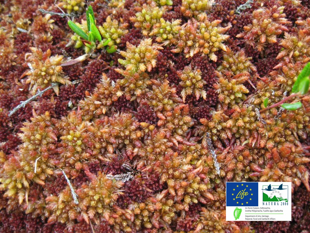
Degraded Raised Bog covers 78.23ha (59.93%) of the high bog area. It is drier than Active Raised Bog and supports a lower density of Sphagnum mosses. It has a less developed micro-topography while permanent pools and Sphagnum lawns are generally absent.
Depressions on peat substrates of the Rhynchosporion are found in both Active and Degraded Raised Bog, but tends to be best developed and most stable in the wettest areas of Active Raised Bog. The bog has a well-developed hummock and hollow system.
The underlying rock is Carboniferous limestone, with overlying gravely glacial till and Lacustrine deposits above this.
Deep peripheral drains surround the bog, some as deep as 4m. Surface drains are also present, mostly on the eastern side of the bog, and some of these date back to the early 1800’s. The structure of the bog habitat has been affected by drainage. Peat-cutting along the margins of the bog has also led to the lowering of the water table within the adjoining, intact high bog areas. Peat extraction has discontinued but old face banks and cutover drainage have caused negative impacts on the high bog habitats in recent times.
Although the north-eastern section of the bog suffered from burning in the past, the majority of the site has been unaffected by this practice in recent years.
Thanks to the LIFE project, the prospects for Raheenmore Bog generally good. Previous works on the bog have yielded positive results, and we aim to build on these. We will publish the results of our works here in 2021.
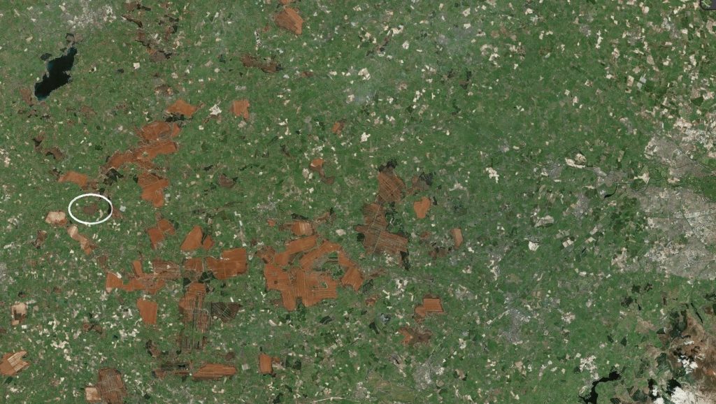
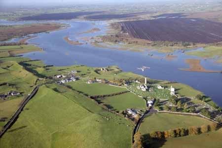
Raheenmore (circled) looking east to Dublin… It’s one of the last relatively intact bogs left east of the River Shannon… Pic: Bing Maps
At present there are no visitor facilities on Mongan Bog. We will post more on open days, guided walks and other events here and on our Facebook and Twitter pages as they arise, e.g. Heritage Week. We have organised many tours on this amazing bog.
You can take in its beauty without engaging in some bog trotting.
The bog is best-viewed from the Pilgrim’s Road, or Pilgrim’s Way, an ancient raised road along the top of the glacial ridge, or esker. From this ancient road, which brought pilgrims into (and out of) Clonmacnoise since the early seventh century, you can look down on the impressive dome of Mongan Bog. The dome may not be as high as it was when Pilgrims visited Ireland’s oldest pilgrimage site, but it is still an awe-inspiriting sight.
 The Pilgrim’s Road offered safe passage to medieval travellers to and from Clonmacnoiseis.
It leads from the monastic core eastwards through the old burial ground and dissects the New Graveyard where it heads towards the Nun’s Church; a small platform of stones known as ‘the Cairn of the Three Crosses’ is visible on its route. It is a key part of the pilgrimage route at Clonmacnoise known as ‘The Long Station’ performed on the Pattern of St Ciarán.
The Pilgrim’s Way from Ballycumber to Clonmacnoise was a part of the Pilgrim Paths Project, set up by the Heritage Council in 1997, in association with local communities, with the objective of developing a network of walking routes along medieval pilgrimage paths. The aim of the project was to raise the profile of the landscape and its heritage, built and natural that is encountered along the routes, while contributing to sustainable tourism and community development in each local area. Work on the Pilgrim’s Way was completed in
2007.
The Pilgrim’s Way demonstrates how the natural attributes of the landscape were used to benefit the development of the monastic city. The Pilgrim’s Way is a further reminder of the sacral nature of the landscape around Clonmacnoise.
You can exit at Clonmacnoise, following the ‘pointer’ signs for about 1km until you reach the rise of the road overlooking Mongan. As you stand in the centre of the road with the bog over one shoulder and the River Shannon over the other, it is one of Ireland’s most impressive sights. You are truly following in the footsteps of ancient pilgrims!
Clonmacnoise is one of the most popular and historic ancient monastic sites in Ireland. A walk amongst the peaceful stone ruins of this famous place will conjure images of the saints and scholars of Ireland’s renowned Golden Age of learning.
Founded by St Ciaran in the mid-6th century, it became a great centre of religion and learning, visited by scholars from all over the world. Many historical manuscripts, including the 11th century Annals of Tighernach and the 12th century Book of the Dun Cow, were written here.
Today, the site exists as a preserved ruin under the management of the Office of Public Works and visitors can see three high crosses, a cathedral, seven churches and two round towers. The beautifully preserved structures of Clonmacnoise Cathedral, Temple Doolin, Temple Hurpan and Temple Melaghlin will impress and leave those who visit Clonmacnoise with an authentic sense of the history of Ireland.
To dig deeper into the fascinating history of Clonmacnoise, visit the on-site interpretive visitor centre, which displays a number of cross slabs and the 9th century Cross of the Scriptures. The Clonmacnoise graveyard surrounding the site continues to be in use, while religious services are held regularly on the site in a modern chapel.
Admission Prices
Adult: €8.00 | Senior/group: €6.00 | Child/student: €4.00 | Family: €20.00 |
Open all year, daily | November-Mid-March, 10:00am-5:30pm | Mid-March-May, 10:00am-6:00pm | June-August, 9:00am-6.30pm | September-October, 10:00am-6:00pm | Closed 25 and 26 December | Last admission is 45 minutes before closing.
VISIT OFFALY
For more on visiting the area, see the excellent VISIT OFFALY page on Clonmacnoise, and whilst you’re there, be sure to look around at the many places in Offaly to visit.

CROSSING THE BOGS
For people visiting Clonmacnoise, crossing the raised bogs would have been precarious as they contain permanent pools on their surface which vary greatly in depth. For this reason the eskers were preferred routes across the landscape. However, man had been interacting with this seemingly inhospitable landscape for centuries. Archaeological excavations have revealed the presence of wooden toghers (track ways) and gravel pathways across the bogs around Clonmacnoise which in many cases predate the monastery and demonstrate that the bogs were not as impenetrable as first thought.
Sadly, the drive for peat as a fuel and horticultural product has ensured that many of these have been badly damaged and/or obliterated.
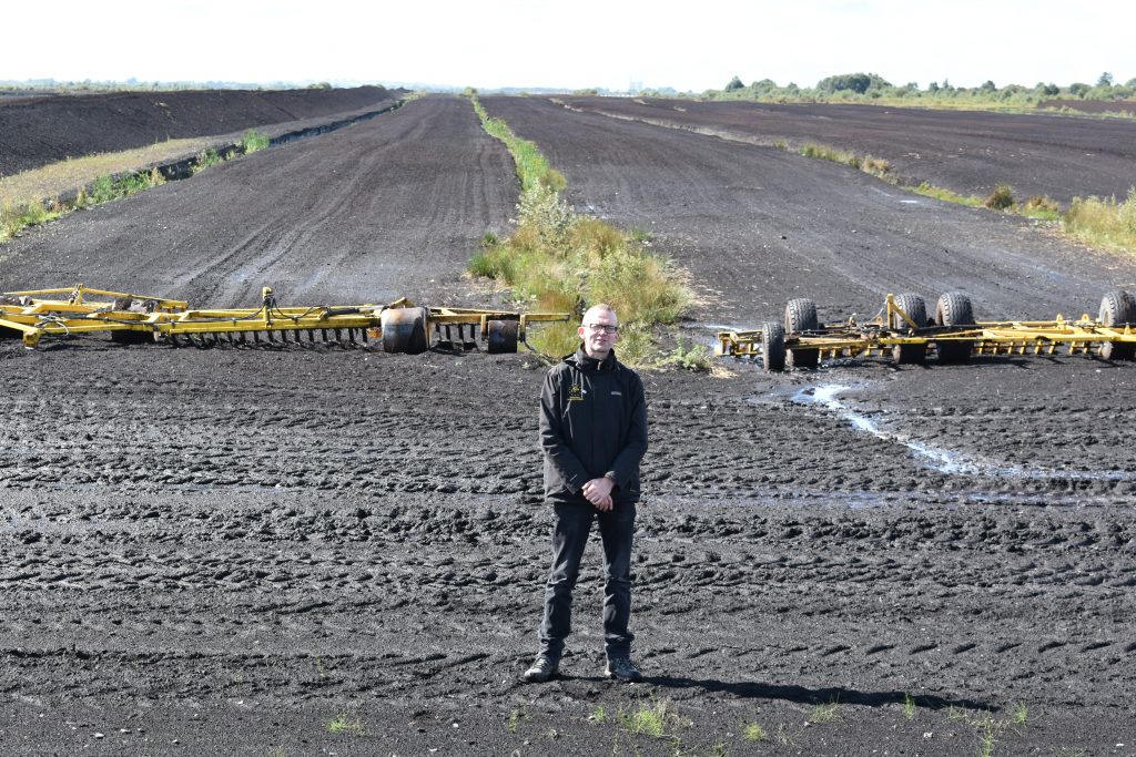
Ronan Casey from the Living Bog team stands at a typical ‘production bog’ close to Clonmacnoise and Mongan Bog SAC. in Co Offaly.