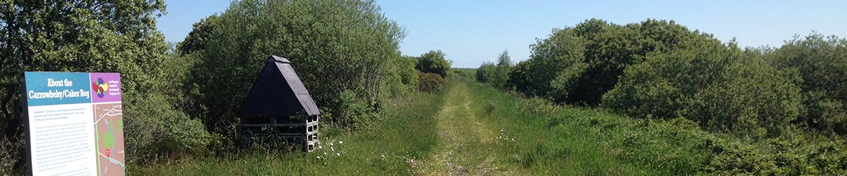
About Carrowbehy / Caher
A large floodplain bog developed in a depression between low drumlin hills in the headwaters of the River Suck, Carrowbehy / CaherBOG SAC covers a surface area of some 343 hectares, making it one of the largest LIFE project sites. Nestled in the heart of the Gorthaganny area, it is a fine bog with visitor facilities.
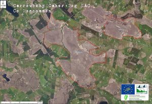
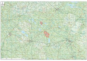
Carrowbehy Bog is located in the western part of County Roscommon, 8km north-east of Ballyhaunis and 9km north of Ballinlough. Interestingly, it lies approximately 5km to the south-east of Derrinea Bog (another of our 12 project sites).
This bog was subject to much restoration work between November 2019 and March 2020 with almost 1,100 dams installed to keep water moving on the bog and lock carbon into its peaty depths.
Unusually, the bog has partly enveloped a drumlin to the north. The site is a good example of a western raised bog.
The bog is composed of four main lobes:
Main Lobe
This is a linear tract of bog running in a NNW-SSE direction. It is bounded to the west and north by streams, to the east by a number of hills and to the south by cutover bog. The eastern part of this lobe extends up over the side of one of the marginal hills. The main lobe is approximately 130ha in area.
North-western Lobe
This lies to the north-west of the main lobe. The area is bounded by a stream on its northern and eastern sides, a hill to the south and by cutover to the west. It is approximately 35ha in area.
Northern Lobe
This lies to the north of the main lobe and is a remnant of a larger expanse of bog, part of which is now afforested. It is included here because of the poor fen which is developed on its south-east corner. It is isolated from the other lobes by a large stream. This part of the bog has an area of approximately 25ha.
Western Lobe
This is the smallest of the lobes (approximately 20ha). It has been isolated from the main lobe by a series of large drains which form its eastern margin. The area is bounded by hills to the south and west and by a large stream to the north.
The bog is the most species-rich of the region with a long list of bog moss (Sphagnum) species occurring in a variety of situations. The main section of bog is intact and features a number of small in-filling lakes, flushes, and a series of swallow holes.
Extensive quaking areas occur throughout the main section and large inter-connecting, steep-sided pools and good, active hummocks also occur. The bog surface is wet throughout, even towards the margin.
1a.**( BOG PIC HERE)
To the west of the main section, and separated by a small stream a smaller circular dome exists. To the north, an area of old cutover adjoins a drumlin and a well-developed bog moss community which resembles the original base-rich ‘lagg’ zone with a gradual transition to bog is found.
Peat cutting is no longer taking place on the site and had ceased by 2003 (Fernandez et al. 2014a, b). Old face banks occur around much of the high bog.
Burning was reported as an impacting activity by Kelly et al. (1993), and again by Fernandez et al. (2005). However there was no evidence of recent burning of the site during the period 2005-2012 (Fernandez et al. 2014a, b).
Carrowbehy / Caher Bog is of considerable conservation value. It is especially important as the uncut high bog at this site is remarkably intact and contains a central, active area. Here, good examples of hummocks occur and there are extensive quaking areas and large inter-connecting, steep-sided pools.
The site contains good examples of the E.U. Habitats Directive Annex I priority habitat *Active Raised Bogs (7110) and the non priority Annex 1 habitat
Degraded Raised Bog capable of regeneration (7120) – as well as the non-priority Annex 1 habitat Depressions on the peat substrates of the Rhynchosporion (7150). Additionally, this site is amongst those most appropriate to reach the project’s objectives because the restoration works previously undertaken have shown some encouraging results. Restoration works took place at the site prior to 2005, including the blocking of several high bog drains.